Mapping Texas: From Frontier to the Lone Star State
Historical Maps Chronicling Birth of Texas Displayed for First Time
 (SAN ANTONIO, TX) – The Witte Museum and Texas General Land Office leaders are excited to announce Mapping Texas: From Frontier to the Lone Star State, a once-in-a-generation, collaborative exhibition covering nearly three hundred years of Texas mapping. The maps, dating from the sixteenth through the nineteenth centuries, document the birth of Texas, the evolution of the physical and political boundaries of the state and the rise of the Alamo and San Antonio Missions.
More than 40 rare maps from the collections of the Texas General Land Office, the Witte Museum and Frank and Carol Holcomb of Houston, will be displayed in this exhibition. Many of these maps are on public view for the first time.
“The Witte Museum curatorial team is proud to work with the Texas General Land Office archivists to display these pivotal Texas history icons, revealing the making of this great state,” notes Marise McDermott, President and CEO of the Witte Museum.
"The GLO is proud to team up with the Witte Museum on this, the largest and most comprehensive map exhibit this agency has ever been a part of," says General Land Office Commissioner George P. Bush. "This collaboration with the renowned Witte Museum is an opportunity to inform new audiences what is available to discover in the GLO Archives. This valuable partnership with the Witte Museum is another example of the multitude of mutually beneficial partnerships between the GLO and the San Antonio community."
Researched by the Texas General Land Office archivists and South Texas Heritage Curator Bruce Shackelford, Mapping Texas runs from April 29 to September 5, 2016, in the Russell Hill Rogers Texas Art Gallery in the Robert J. and Helen C. Kleberg South Texas Heritage Center at the Witte Museum. All labels were researched and written by José Adrián Barragán, PhD, Spanish Translator for the Texas General Land Office. 
Mapping Texas: From Frontier to the Lone Star State focuses on important phases in the cartographic history of the state including European discovery, western expansion of the United States, the settlement of the frontier through empresario contracts with the Mexican State of Coahuila y Texas, the limits of the Republic of Texas and the changing boundaries of San Antonio and Bexar County.
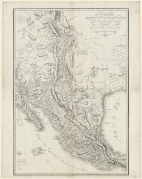
For the first time ever, three of the most important maps of the “Father of Texas,” Stephen F. Austin, are brought together representing his contributions to the cartographic history of the state. Austin’s 1837 “Connected Map of Austin’s Colony, 1833–1837” is a prominent feature of Mapping Texas: From Frontier to Lone Star State. This map depicts the original land grants issued within Austin’s Colony, which became the model for subsequent land ownership maps housed at the Texas General Land Office.
Mapping Texas: From Frontier to the Lone Star State exhibits, also for the very first time, the manuscript drafts of the surveys of the Texas-U.S. Joint Boundary Commission. Three different sheets, more than 14-feet wide, trace the Sabine River from its mouth in the Gulf of Mexico to Logan’s Ferry in the north, near present-day Logansport, Louisiana. A second set of maps follows the Boundary Commission survey in a straight line due north from west of Logan’s Ferry on the Sabine to the Red River. The boundaries established by these surveys were recognized when Texas entered the Union in 1845.
“This exhibition is unlike anything you have seen. The maps and related artifacts are rare and fragile, making this an experience that you cannot get anywhere else,” says Bruce Shackelford, South Texas Heritage Curator of the Witte Museum. “You will be getting a rare, up-close opportunity to discover Texas at its earliest stages, including a fascinating look at the history of the Alamo and San Antonio’s Missions.”
As part of this exhibition, at 2:00 pm, on Sunday, July 17, the Witte Museum is proud to offer a special Louis A. and Frances B. Wagner Series presentation with South Texas Heritage Curator Bruce Shackelford, collector Frank Holcomb and a panel of scholars from the Texas General Land Office. The presentation will take visitors back in time to the transformation of Texas as shared through the eyes of nationally renowned cartographers.
Mapping Texas: From Frontier to the Lone Star State is presented in collaboration with the Texas General Land Office, and is generously supported by the City of San Antonio Department for Culture & Creative Development.
About the Witte Museum:
Founded in 1926, the Witte Museum is located on the banks of the San Antonio River in Brackenridge Park and is San Antonio’s premier museum promoting lifelong learning through innovative exhibition, programs and collections in natural history, science and South Texas heritage.
About the Texas General Land Office:
In 1836, the Republic of Texas Congress formed the General Land Office to manage the public domain. The charge was to collect and keep records, provide maps and surveys, and issue titles. Created in 2004, Save Texas History, a project of the Texas General Land Office, is dedicated to preserving and promoting the historic documents and maps of the General Land Office Archives, serving as a teaching resource for Texas history education, and serving as a resource for digitizing Texas history.
###
Date and Time
Friday Apr 29, 2016 Thursday May 5, 2016
Location
Witte Museum
Fees/Admission
FREE
Contact Information
Katye Brought
Send Email
